Ad

Ad

Progress for group 0 ad

Munir Shemsu
Addis Ababa, Ethiopia
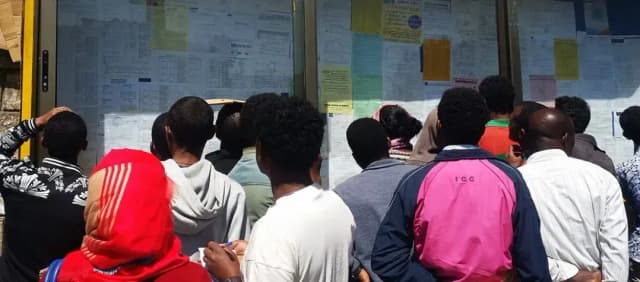
Seven-year-old company Bandira AddisMap Enterprise (BAME) has launched a public transport route management app after comprehensively mapping out the capital’s public transport network.
Boosted by a $30,000 fund secured by winning the Digital Transport 4 Africa Innovation Challenge two years ago and a collaboration with the Trufi Association, an international NGO promoting easier access to public transport, the platform is developed for people who need to go somewhere in the city but don’t know which public transport to use.
The app, AddisMap Transit, includes the Light Railway System (LRT), 199 Anbessa and Sheger Bus routes across 1,220 stations, along with 247 minibus taxi routes and 953 stations.
The startup, which provides innovative Geographic Information Systems (GIS) solutions to businesses, governmental organizations, tourist attractions, and the general public, has made the platform free to use on Android and iOS. It offers urbanites optimal transport alternatives, helping users find the best way to get from point A to point B.
Alazar Tekle, project manager at BAME, said a vast area of potential expansion was identified during the data collection period. He called on developers to utilize the open data, disaggregated by factors such as gender and safety, to further improve Addis Abeba’s public transport management.
“Our revenue targets rely on long-term integration with other systems,” Alazar told Shega. He expects wide adoption of the application to align closely with the increased focus on public transport by the City Administration. “People will be spared from taking three minibusses if one bus can get them there,” Alazar said.
Related- Institute to Unveil Ethiopia’s First Digital Addressing System
The app, released as open-source on GitHub, extracted the transport routes from OpenStreetMap (OSM), leveraging open-source code developed by Trufi that converts OSM data to General Transit Feed Specification (GTFS), a standardized format used by public transit systems to publish their schedules and geographic information, making it easier for applications to understand and use the data.
According to Turif, accurately mapping public transport routes using OpenStreetMap (OSM) is an advanced skill that is challenging to execute accurately. With funding from the DT4A Innovation Challenge, AddisMap Transit mapped, remapped, and validated the data in OSM.
BAME, formerly known as YeneGuzo, is also looking to enable real-time bus arrival data on the app in the short term. Established with a modest capital of 250,000 birr from a pool of friends, BAME now aims to enrich its commercial prospects with more value-added services. However, the developers acknowledged that the app’s availability in just two languages (Amharic and English) could be limiting in the capital’s peripheries.
Share this post:
Munir Shemsu
At Shega, we do more than tell stories. We help you make an impact. Our platforms, data, and expertise connect brands, organizations, and investors to the audiences and insights that matter.
Reach, engage, and grow with us.
Get in Touch
Undercurrents of USAID Funding Freeze in Ethiopia
01 March 2025

ECMA Opens Door to Capital Market Innovation with Launch of Sandbox1
24 November 2024

Ethiopia’s Delicate Dance with Personal Data Protection
24 August 2024
Latest Stories
22 December 2025
𝗗𝗲𝘀𝗶𝗴𝗻𝗲𝗱 𝗳𝗼𝗿 𝗪𝗵𝗼𝗺? 𝗧𝗵𝗲 𝗠𝗶𝗿𝗮𝗴𝗲 𝗼𝗳 𝗪𝗼𝗺𝗲𝗻-𝗖𝗲𝗻𝘁𝗿𝗶𝗰 𝗗𝗶𝗴𝗶𝘁𝗮𝗹 𝗙𝗶𝗻𝗮𝗻𝗰𝗲 𝗶𝗻 𝗘𝘁𝗵𝗶𝗼𝗽𝗶𝗮 QA
By Chilen14 December 2025
From Campus Idea to Satellite TV: Ethiopia Gets Its First Home Shopping Channel QA test
By ChilenLatest Stories
𝗗𝗲𝘀𝗶𝗴𝗻𝗲𝗱 𝗳𝗼𝗿 𝗪𝗵𝗼𝗺? 𝗧𝗵𝗲 𝗠𝗶𝗿𝗮𝗴𝗲 𝗼𝗳 𝗪𝗼𝗺𝗲𝗻-𝗖𝗲𝗻𝘁𝗿𝗶𝗰 𝗗𝗶𝗴𝗶𝘁𝗮𝗹 𝗙𝗶𝗻𝗮𝗻𝗰𝗲 𝗶𝗻 𝗘𝘁𝗵𝗶𝗼𝗽𝗶𝗮 QA
22 December 2025
From Campus Idea to Satellite TV: Ethiopia Gets Its First Home Shopping Channel QA test
14 December 2025

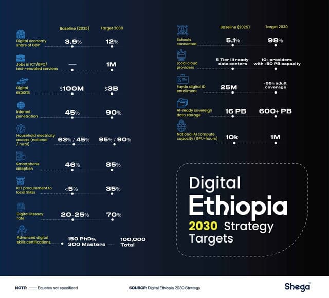
𝗗𝗮𝘁𝗮 𝗦𝗼𝘃𝗲𝗿𝗲𝗶𝗴𝗻𝘁𝘆, 𝗧𝗲𝗰𝗵-𝗦𝗮𝘃𝘃𝘆 𝗖𝗶𝘃𝗶𝗹 𝗦𝗲𝗿𝘃𝗮𝗻𝘁𝘀 & 𝟭 𝗺𝗶𝗹𝗹𝗶𝗼𝗻 𝗜𝗧 𝗷𝗼𝗯𝘀: 𝗨𝗻𝗽𝗮𝗰𝗸𝗶𝗻𝗴 𝗘𝘁𝗵𝗶𝗼𝗽𝗶𝗮’𝘀 𝟮𝟬𝟯𝟬 𝗗𝗶𝗴𝗶𝘁𝗮𝗹 𝗥𝗼𝗮𝗱𝗺𝗮𝗽 on Qa strapi
11 December 2025
Undercurrents of USAID Funding Freeze in Ethiopia
01 March 2025
ECMA Opens Door to Capital Market Innovation with Launch of Sandbox1
24 November 2024
Ethiopia’s Delicate Dance with Personal Data Protection
24 August 2024